Survey Your Property Line With GNSS RTK
Let’s perform a survey on our property using GNSS RTK accuracy. Real Time Kinematics allows you to achieve 1 centimeter of accuracy in finding a location.
The absolute first thing I need to say about this is that doing your own survey does not provide official results unless you are a licensed surveyor.
All 50 states require a Surveyor to be licensed to perform such services as I’m describing here.
That being said I bought the home where I currently reside a few years ago in a private sale. I only have a rudimentary understanding of my actual property line. It is not marked as far as I can tell. If there are survey markers in the ground I’ve never seen one and I believe this area had its parcels defined in the late 1950’s.
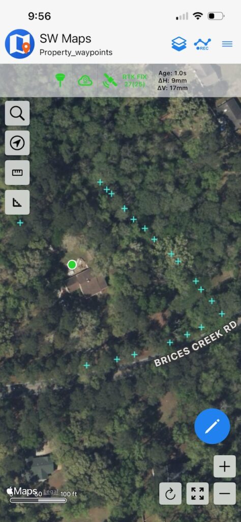
Just from the satellite pic with my property waypoints that I obtained from official County documents and files I have a way better understanding of my boundaries.
Let me try to demonstrate how I did this.
Conversely, I have to say this again. If you are involved in some kind of property line dispute no court will accept your findings here as official. Even if your results mimic an actual survey, they probably won’t stand up. I’m confident that even with the heavy tree cover I can get within a foot or two of each point.
That will change soon as a company called RTKdata is going to allow me to install one of their RTK Base Station antennas on my property. At that point my rover will be within range of the base station at all times and I will have 1 centimeter accuracy.
I should state that RTKdata is going to send some operations folks out to my home to see if it is acceptable for their RTK network. I think it will be.
My Personal Situation Here
I have no issue with my neighbors whatsoever. Also, I have no compelling reason to complete a survey other than to satisfy my own curiousity. My goals here are:
- Learn how to obtain GNSS RTK skills and to use them in a practical manner.
- Learn what the boundaries of my actual property are.
- Demonstrate to my readers how I accomplished it.
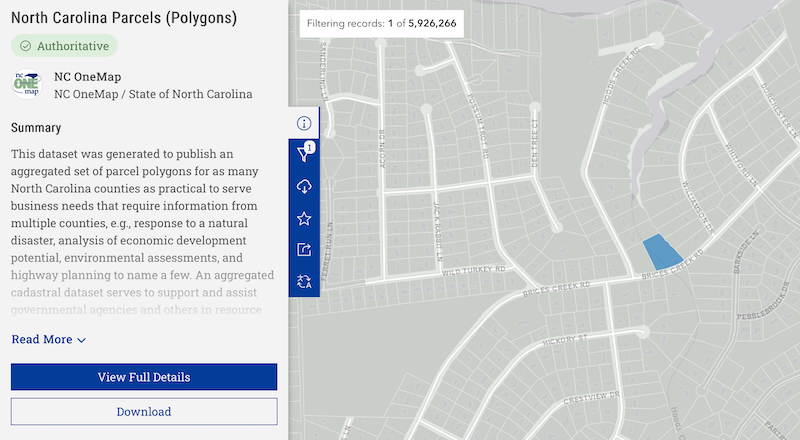
Find Your Parcel Info On Government Sites
My particular parcel information for NC was found at the NC One Map site. More specifically my parcel map was found here.
If a picture is worth a thousand words, a video is worth a million. Here is how I did it. The end step with SW Maps will be just a bit further down the blog.
Time For The GNSS RTK Magic With SW Maps
Now that we have a shapefile with our survey points that indicate our property boundary it is time to import that into SW Maps so we can use it with our rover to get 1 centimeter accuracy. Hopefully, as I have heavy tree cover around my home. Here is a link to my rover setup.
The video below demonstrates how to transfer the shapefiles over to SW Maps.
Time To Take A Walk
Once your rover is connected to SW Maps and has connected to an NTRIP server, ensure that you are getting an RTK Fixed indication. Here is what happened when I went to look for my first point. First you click on any X and then there is turn looking arrow which navigates you precisely to that point.

I navigated to the point at the bottom left for this demonstration. Here are my results.
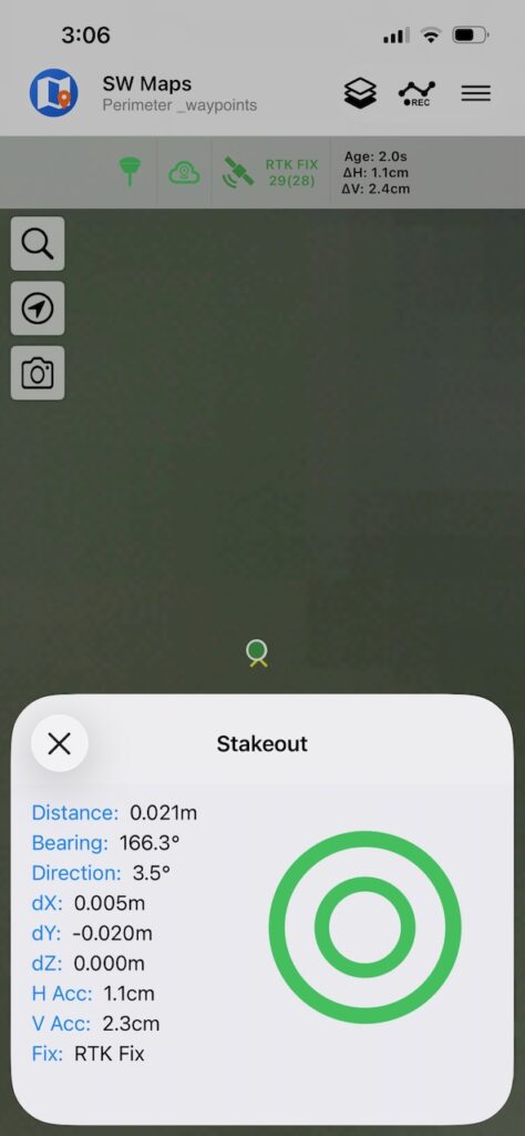
You can see a little X sticking out of the green circle. When I would set the rover down on the ground I guess it was losing some awesome impedance from me and would pop in and out of RTK Float and RTK Fixed. If I got it close and goosed it a hair it would bounce around a bit and then try to decide if it was RTK Float or Fixed. I should say I have pretty substantial tree cover here.
Wrapping Up My GNSS RTK Surveying Experiment
I’ve learned a lot over the last couple of weeks and the fact that I can now go out and mark survey points to define my property boundaries with some fairly decent degree of accuracy is amazing to me. And my rover is handheld with a small antenna. If I had a proper rover mounted on a survey rod and an NTRIP base station next door I’d be dead accurate.
That’s a really interesting approach to boundary marking. I’ve heard RTK accuracy is a game-changer for precision work like this, especially for complex lot shapes.
Cautionary notes:
1) accuracy of the county parcel “surveys” is VERY variable. In some cases they are NOT based on any actual survey data, rather being copied from ancient “tax maps”. A friend in NC found his downloaded parcel lines were wildly off… Inspect the source, compare it to what the deed says; search the county registry for any “Plans” which are real surveys; also look at abutting parcels..
2) Hopefully you are fortunate enough to find actual registered survey plans; they will probably be based on the local (e.g., NC) State Plane Coordinate System. I believe my friend in Macon County, NC, used EPSG:2264 “NAD83 / North Carolina (ftUS)” which is a Lambert Conformal Conic projection tied to NAD83.
3) Be aware that EPSG:4326 “WGS84”, which is used for GPS, is locked to Greenwich, UK, while State Plane Coordinate Systems are locked to the US continent (which moves away ~ 1 inch/year). QGIS warns that conversion from EPSG:4326 to NAD83 based systems can be off by 1 meter…
4) the real key to “georeferencing” a plan is to find some “monuments” such as iron pins (IP), stone bounds (SB), blazed trees, etc., which show up both on the plan and on the ground. My friend used your approach to guide him to the approximate locations, then did a careful search to find IPs and the like.
He then used QGIS to display the actual pin locations and then to rotate/pan the plan to align with the pins.
Thanks for the awesome input! I’m new at this and appreciate all the input I can get!