Capturing NOAA Satellite Imagery With RTL-SDR
NOAA Satellite Imagery
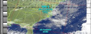
In this entry I’ll show you how to grab NOAA Satellite Imagery. There are still 3 operational satellites. NOAA 15, 18, and 19. NOAA 15 started acting up last October but is still functional. The pic just to the left is from NOAA 15.
Did you know that ANYONE with the right hardware can download telemetry from these satellites?
Not only that, it can be done pretty cheaply. All it takes is a computer, an antenna, a USB RTL-SDR device, and some free computer software.
It isn’t that difficult either but does take some time to get it working correctly.
And for the purposes of the blog, I am doing this on a Linux (Ubuntu) laptop. But you can do it on Windows as well.
Why Do This?
Granted you can watch the local news or grab your phone and get all kinds of weather data at a moments notice. But what if the grid goes down, even for a short time? At least one person in your circle should know how to do this. Even someone with minimal knowledge of meteorology can see a Hurricane coming, or bad weather patterns.
Or you can tell if it will be sunny or cloudy in the coming hours. This kind of information could be vital to planning in the event of an emergency or degraded conditions.
NOAA Satellite Required Items
- Computer
- RTL-SDR
- Antenna tuned to approximately 138 MHz
- Satellite Prediction Software
- Software for RTL-SDR
- Software to convert audio file to NOAA Satellite Imagery
Tracking
One of the most key elements to doing this is knowing when the satellite will be within range to grab the telemetry. Some people track online. I personally use a program called GPredict.
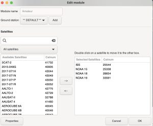
GPredict
You need to set your Station location in GPredict so it knows how to anticipate the passes. And you want to make sure the TLE data is up to date. Go to Edit > Update TLE From Network. Then you need to add the mix of satellites you are tracking. I only track the NOAA Satellites and the ISS. If you put too much stuff on the screen it gets too busy.
Configuration
RTL-SDR And Antenna
Almost any RTL-SDR will work, but this is a good one. The antenna is an entirely different story. Some people make their own and it is stationary outside. I personally like to use a handheld antenna. I bought mine from Arrow Antenna. According to their website you have to contact them for Satellite antennas. Well worth the money.
Mostly you are left to your own devices here. You can build a DIY QFH antenna which is stationary and should give you great images from most passes that are in range. Google is your friend here.
Signal Capture Software
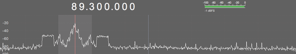
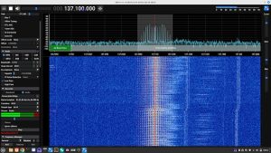
SoftWare SDR++ (click pic to enlarge)

I use SDR++ . To decode NOAA satellites make sure to set your radio to Narrow FM (NFM) and set your bandwidth to about 40K (40000). There are dozens of settings here and some folks get deep in these weeds. I do not. NOAA bird frequencies are as follows:
- NOAA 15 – 137.62 MHz
- NOAA 18 – 137.9125 MHz
- NOAA 19 – 137.1 MHz
Also near the upper right of SDR++ you’ll see a “Zoom” slider. Crank it up a bit so you can see what is going on. The real benefit of this is that during the decode you will need to keep the bandwidth centered on the signal which drifts slightly due to the Doppler Effect. If you look real close at the image above you’ll see mine is slightly off center. This is not an issue, however if it drifts too far off center it will be.
It also pays to take note of where north and south are at your location. Trying to find a signal emanating from a cardinal direction and having no clue where that cardinal direction is no fun at all. Minimize your search area. I have a solar panel in my backyard which faces due south. Guestimating North, East, and West is much easier.
The Signal
The signal looks like this. It also pulses and makes an interesting ticking noise.
APT Signal From NOAA Satellite
Recording The Signal
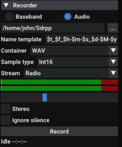
Record Pane
If you scroll down just a hair you’ll find the “Recorder” pane. Set your container to WAV and uncheck the Stereo box.
Just below the double green lines you’ll see an unmarked blue slider. That is your recording level. Make sure you are in the green as the signal pulses.
On my particular laptop I have to keep the recording level about halfway up the scale or the recorded audio is too loud and clips atrociously.
I’ve done this on a half a dozen laptops and I can tell you that every one behaves wildly different. It takes a bit to find the sweet spot .
In fact, I’m just going to say that you probably will not have a ton of success the first few times you try this.
Anyway, when your prediction software says the bird is in range, go hone in on the signal and keep the level as high as you can throughout the pass. Passes are usually in range for 12-15 minutes, however, I have found that it pays to wait a minute until the signal gets strong and to bail out of the capture a minute or two earlier before it starts getting too weak. Yeah, you’ll loose some data on the top and bottom of your grab but you’ll get a much cleaner decode.
Image Processing Software
This is the most complicated part. Years ago there was some excellent software for decoding called WxtoImg. The project has been abandoned, however you can still download the software from the WxtoImgRestored website. When the project died they did provide free registration keys so it can still be used. I bought my keys long before the project died.
Let me say this about WxtoImg. The NOAA birds haven’t changed since they were put in orbit. The old abandoned software still works JUST FINE.
But.
There is always a but. The process they used to update the TLE and Kepler data DOES NOT WORK ANYMORE. If your Kepler data is out of date it simply will not ever process an image correctly. It has to be manually done. I use an excellent script called “Weather-Satellite”
This Is For Linux
Download his weather.sh script. I put mine in a folder called Kepler_Update. You launch the file like this (change your storage location if yours is different).
cd Kepler_Update
sh weather.sh
It will then grab the latest weather.txt file from Celestrak.org and move it to the appropriate folder. It will then launch WxtoImg. Conversely, If you start your program like this, it will always be up to date.
Ground Station
Go under Options > Ground Station to set your Latitude and Longitude. There are a ton of things you can do here but this blog is taking a minimal approach. Grab a signal, make a picture.
Audio Conversion
You cannot just open the WAV file in WxtoImg. It must first be resampled to 11025 Hz. There are LOTS of ways to do this but there is one big GOTCHA. The timestamp of the file. If you process your audio file and it contains a different timestamp (and it will), WxtoImg will get mega confused and not build a proper pass to decode the image. Here is how I do it. When you record in SDR++ or GQRX or whatever software you use you’ll get a fairly lengthy file name. It must now be resampled. I use the command line to do this. Some people use Audacity. Command line is quicker and easier, I think. First install a program called sox.
sudo apt-get install sox
Now type the following:
sox inputfilename.wav outputfilename.wav rate 11025
I usually name my output file name “noaa15_1.wav” and then of course 2, 3, 4, etc.
Here is the IMPORTANT part. Noaa15_1.wav needs the same timestamp that the original file has.
touch -r inputfilename.wav outputfilename.wav
Bob is now your Uncle. Open WxtoImg and open the audio file you just made (e.g. NOAA15_1.wav). Now go to File > Decode. You should see an image.
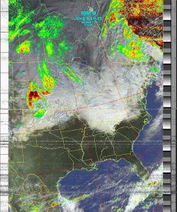
NOAA 18 southbound
Or this image:
Capture
You’ll notice some static lines in my image. That comes from not staying on the signal optimally. Hey, I haven’t done this in a few years :). After a bit you’ll kind of get some muscle memory and your images will improve dramatically. Seriously, you get the feel for how the satellite is moving across the sky when you are following it with a handheld antenna. IT TAKES PRACTICE.
Considerations
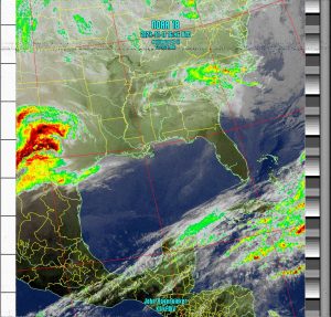
I’m a hobbyist tech geek. I WANT crisp, perfect images But let’s say the SHTF in a big way. The image above contains way more than enough data to tell me what might happen to me in a few hours or the next day. See the yellow + sign in North Carolina? That’s me. You can see the giant storm tracking away north of me with relatively clear stuff rolling in behind. I’m no meteorologist but this gives me enough visual information to aid in planning.
Interference
I haven’t done this in some time and I felt like the audio signal had way more static than I remembered. It was around sunrise I was doing a grab. My backyard lights are smart lights. My wife was leaving for work and said the magic words. “Alexa, turn off back yard lights”. All the interference went away instantly.
Summary
This is a fun project and in my opinion this is good skillset to have if things go bad for any length of time. I live right in Hurricane Alley.
With a $30 RTL-SDR device and an antenna you can actually receive data from functional weather satellites. While the GOES satellites give better resolution and wider, continual coverage, the NOAA birds still give you the information you need. The rough steps are:
- Record audio signal from satellite
- Resample the audio to 11025 Hz
- Open resampled audio in WxtoImg
- Decode
Thanks for the info on this project! Is there a pure Linux solution for this or is WxtoImg the only way to go?
I’m considering getting a quadrilinear antenna set up just for catching NOAA passes but I haven’t found a good source for them. Looks like the only route is DIY.
I’m just now finding your blog and enjoying the tech projects. Looking forward to more updates!
Cheers,
Mark N4JMT
Raleigh
P.S. My blog also has some interesting projects, so please check it out. 73!
Thanks! Check out a program called SatDump. I believe there is a WXtoIMG Windows solution as well.
Whoops, meant a QFH antenna. Reddit to the rescue! https://www.reddit.com/r/RTLSDR/comments/8biful/is_there_any_place_to_buy_a_decent_137_mhz_noaa/
Fun fact: I created the first Linux package for GQRX.
Very Cool. I love GQRX and it was easy enough to use in my early days of doing this stuff. GNURadio is much tougher.
Hey, send me your blog. You probably did on your initial post but I think I have url’s filtered on submissions here because I get a ton of people who are obviously advertising stuff. I post about bicycles and their comments are specifically to drive you to their online casino or something. That kind of thing.
Pingback: Rádiózás - új hobbi - aryxs3m