Cammenga 3H Tritium
Yeah, this is a Tech blog but sometimes you just gotta be old school. Compasses are pretty old school and in fact the first compass known was about 206 BC! And they were used for navigation first around 1040 AD.
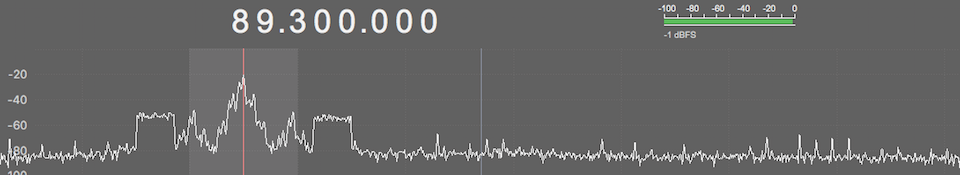
I use a compass to align satellite dishes. Radio is my hobby and I track satellites such as Inmarsat or NOAA GOES Weather Satellites for fun.
Every phone has a compass but I find them to be wildly off, at least on the iPhone. However, if you dabble around on the internet other users will tell you they nail satellites with iPhone compasses all the time. THIS HAS DEFINITELY NOT BEEN MY EXPERIENCE. They either posses great skills or are lucky as heck. Or maybe it is geographical. I dunno.
But I do know a real compass works just fine and a real compass doesn’t need a battery charge or has a screen that’s hard to see in direct sunlight.
And here is the theme of this blog entry: MOST PEOPLE HAVE NO CLUE HOW TO USE A COMPASS AND THIS IS AS VALUABLE A SKILL AS SWIMMING, RIDING A BIKE, HUNTING, FISHING, ETC. IF YOU CAN’T USE A COMPASS YOU’RE DOING IT WRONG.
Yeah, you’re laughing at me. But you laughed at me before the Hurricanes, and you laughed at me before COVID 19. This Country Boy™ can survive.
Let’s learn some more about the humble compass……….
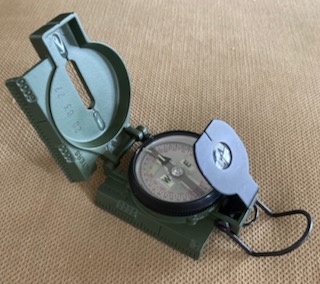
Soon as I figured out my iPhone was not very accurate for satellite pointing I went to the internet and did some research and it seems compasses range from cheap to expensive, with not a lot of in between. I just wanted a compass so I went cheap and got this one off of Amazon.
Chinese Compass
So, I get this compass, it looks fairly solid, and I was able to find all kinds of known satellite positions with it. Worth every penny of the $25 I paid for it.
If all you are doing is finding a known bearing, or trying to find magnetic north this is your Huckleberry. Also if you are a SKILLED woodsman you can probably use this compass better than I can use a super expensive one. A mediocre tool in the hands of a skilled user is better than mediocre.
That being said if you try to use this compass for anything too trying you’ll quickly wish you had invested in a more expensive one. The bezel is WAY TOO LOOSE. It spins way too freely. It is also hard to read looking down at least for my old eyes. The lens that you look through (black round thing by the bubble level) is very easy to read though.
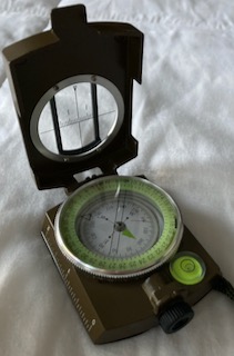
Eyepiece on Chinese Compass
Very legible indeed. Took this picture aligning my satellite dish and it was a piece of cake to find 186 degrees which is where I was supposed to point to.
And of course while you are looking though the eyepiece you can’t see the bubble level although I don’t find this to be super critical.
But again the ease of which the bezel rotates is troubling. You can move it just by closing the lid. Not good if you are navigating and trying to keep the dog in the dog house. (That’s a compass users term and one you’ll hear quickly if you pursue advanced compass knowledge). Basically what it means is that you set your bearing by encapsulating the north pointing needle between a set of lines or a single line while pointing at the bearing or azimuth you intend to follow. As long as North is “in the dog house” you are walking along your course. Of course if the bezel moves………well………you are lost.
So I want to do some more advanced stuff so I felt like I needed a better compass. Quick background. I am a certified Rescue Diver and my compass skills are essentially underwater skills for doing search and rescue. That is a WAY DIFFERENT ballgame than Land Navigation. But the endgame is roughly the same. Follow a course using a compass.
I did all the requisite homework and decided the best compass for me was the Cammenga 3H compass with Tritium. What’s Tritium? It is a radioactive substance that glows in the dark without needing a light charge.
Here’s my Cammenga 3H. Pics in order are:
- In the package
- Date Code. 20= year of manufacture, 03=month, 77= batch number
- Compass set up.
- Tritium glowing in the dark.
Cammenga 3H


")

The Cammenga 3H is a military issue compass and while it has the NSN engraved right into it, it took some digging to find the Mil-Spec. It qualifies to MIL-PRF-10436N. It is a good read and gives you an idea how it is designed and the testing parameters it has to meet, right down to the requirements for the pouch it comes in. Here is another good read. The Cammenga Precision Lensatic Compass Instruction Book – 2016.
I bought mine from Amazon and paid $88.50 for it. Directly from the manufacturer it costs about $105. I took a chance and luckily got a manufacturers date of Mar 2020. The tritium luminosity is supposed to last for a minimum of 12 years according to the Mil-Spec.
The bezel does not move easily and clicks in graduations of 3 degrees. If you are functioning in the dark with the tritium lit dial you can count the clicks and KNOW how many degrees you moved the pointer.
I love this compass! One thing you’ll hear people mention in reviews is that it doesn’t compensate for declination. Declination is the difference between True North and Magnetic North (that’s an oversimplification of it, let’s leave it at that).
In reality if you orient your topographical map along the magnetic declination line YOUR MAP IS ORIENTED. Your compass points to Magnetic North. Simply lay the compass on the map, with the compass straight edge aligned on the “MN” mark on the Declination box. Turn the map until it points to magnetic north and NOW you can start plotting and planning courses and shooting back azimuths and stuff.
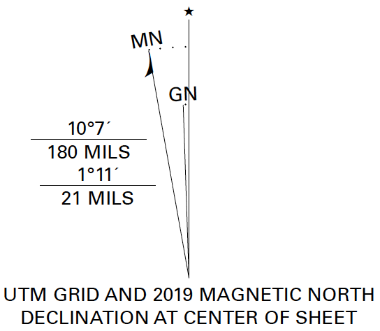
Declination for New Bern Topographical Map USGS
Where this could get tricky is if you were using a street map or something that didn’t have a declination marking on it. It would probably still have a North Star on it though. So if you were in New Bern wandering around in the forests with a street map you would always be off about 10 degrees to the west, (10.7 to be exact). You would need to compensate by adding or subtracting that amount from the bearing you were headed. East declination is a positive number and West declination is a negative number.
After reading about a million reviews before I bought this I came across the following other complaints:
- It’s not accurate enough. Degrees are marked in 5 degree (red marks on the compass) graduations. NONSENSE. This is a military compass and the military uses mils (black marks on the compass). There are 6400 mils to a circle and only 360 degrees to a circle. Mils are WAY more accurate. The deficiency lies in the USER not knowing how to read Mils. Again THIS IS A MILITARY COMPASS.
- It’s not accurate enough Part Deux – The required degree of accuracy is 40 Mils which is 2.25 degrees. YOUR COMPASS MAY BE OFF AS MUCH AS 2.25 DEGREES. Okay, so what? The military trains personnel to operate within a 3 degree margin of error. Again, THIS IS A MILITARY COMPASS. If your objective is a mile or two or five away then 2.25 degrees is not that much and if you have a topo map that indicates landmarks then 2.25 degrees is NOT A PROBLEM. Following a bearing or azimuth requires input from maps, and landmarks and COMMON SENSE.
- It’s too heavy. Yep, it’s a stout piece of gear. Have you ever hung out with military guys in the field? Gear takes abuse and gets tossed around and dropped. Having a good, solid piece of gear means added weight. Again, THIS IS A MILITARY COMPASS.
Another one of the most favorite compasses out there is the Suunto M-3. Guess what it’s accuracy is? 2.5 degrees. Less accurate than the Cammenga 3H at 2.25 degrees. That’s kind of the norm for an unmounted compass.
I used to hike out into Joshua Tree National Park on straight compass headings FOR SEVERAL HOURS. and follow the back azimuth for returning. Allowing for some deviation I would sometimes walk back to the parking lot and be a COUPLE OF BLOCKS AWAY. But I got back, AND I knew and could see where I was. Lets say that your compass WAS OFF 2.25 degrees and you followed that deviation. At four miles out you’d be just over 800 feet away from your target. That’s not that bad. At 1 degree off you’d be just over 300 feet away.
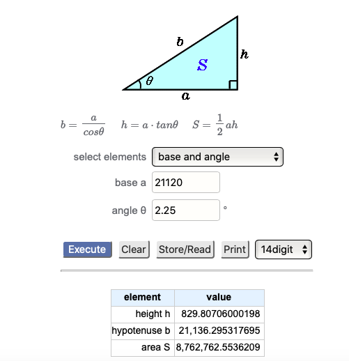
Deviation of 2.25 degrees over a 4 mile distance
I think a lot of these comments, WHILE TECHNICALLY ACCURATE, are over analyzed horseshit. If you demand perfection buy a GPS and pray the batteries don’t die or the satellites don’t hiccup.
Compasses are NOT exact or perfect but they’ll save your bacon if you have one and you know how to use it.
I’m not going to go into any great detail about navigation here because there are SO MANY videos on YouTube on how to use a Lensatic Compass. Land Navigation can’t be learned from one web page. It is a skill that must be practiced and of course you need maps. Bear in mind you can download them free but they must be printed out to be used on the trail and you probably don’t have a printer that big to print them to scale. They are usually 22″x 27″ or 23″ x 27″.
Anyway, get a compass………..learn how to use it. Or get lost and die when the SHTF. And do we really not think the S will not HTF now anymore?
For satellites I like the Suunto MB-6. It offers a decent sight for the target but the manner of reading the azimuth is quite clever. A built in mirror drops from the bottom of the case when extended showing the full circumference of the compass from below. The real kicker for sats is the built in elevation or inclinometer. Rotate the compass 90* along the axis and the sight still works but the mirror now shows the inclinometer!
I’ve used the MB-6 quite effectively for hitting Amsats which are much more difficult than a geostationary satellites as the path duration may only be a few minutes and they move quite quickly.
I am very familiar with the 3H as well. I managed to pass the SFAS star course using this very unit and it achieves the design goals. To that point, the theoretical precision of the compass is one thing but more significant is the application. Land-nav on foot, your precision as a human being walking in a straight line in the dark through rough terrain is far more pertinent than the compass. The question of precision also misses the point of technique. When navigating by map and compass it’s necessary to study the map and identify checkpoints, guardrails and backstops. If you are lucky you will have a nice clear point to gain a fix – a radio tower nav light at night for example. If not, you are relegated to general azimuth, reading terrain and land features to fix position on the map. For example if I have to move 10k to a point on the map, I’m not relying on pure azimuth. I will identify an adjacent significant feature – road / lake / stream / structure, and use terrain mapping and azimuth to bring me to that point which is within the vicinity of my intended target. Once I arrive at the known identifiable point ideally my final distance to target is under 1km or better, under 500m. At that distance I can rely on pace count and compass azimuth to bring be close enough to visually identify the target point. As the distance increases it becomes necessary to leap frog from intermediary checkpoints to verify course and work in. A mistake many new compass users will make is focusing too intensely on the compass and ignoring the bigger picture. The compass is an essential tool but it belongs to a suite of information that must be processed in total.
I have used this lensatic military compass when hiking. I used this to orient topographic maps by adjusting its declination. Lensatic compass is widely used in the military, and it has also proven its usefulness in outdoor recreational activities.
You can use the center-hold or compass-to-cheek methods to read a lensatic compass. In essence, it performs comparable duties as an engineer lensatic or directional compass.